The Living River introduces one species each week from the St. George River watershed — its life, its role, and its place in the long human story of this land. Posts appear below in the order they were published, grouped by month. New to the series? Start with the introduction.
May · The River at Peak
The series begins. The river hits its peak. Everything is moving.
- The River's Silver Messenger: The AlewifeA keystone fish that delivers marine nutrients deep into the forest. Published May 12.
- The River's Black Diver: Double-crested CormorantA prehistoric-looking bird that arrives with the alewife run. Published May 14.
- First Bloom, First Fruit: The ShadbushWhite flowers against bare gray branches — and a name tied to the fish running below. Published May 19.
- The Leap of Faith: The Wood DuckDucklings that jump 50 feet on their first day of life — and shake it off. Published May 26.
June · Long Days, Quiet Water
The water is warm, the days are long, and the river is full of secrets.
- FiddlheadsThe St. George River's Springtime Scrollwork
- Older Than the AtlanticThe Sea Lamprey of the St. George
- The MayflyBorn in the River, Gone in a Day
- Sun, Shell, and Stillwater: The Painted TurtleA living artifact basking on Maine's logs for millions of years.
- Before the Dinosaurs: Horsetail on the Banks of the St. George350 Million Years at the Water's Edge
July · Look Closer Than You Usually Do
Summer on the quiet water. Look closer than you usually do.
- Life in the Fast Lane: The Blacknose DaceA small native fish that monitors water quality for free, every day.
- The Stream's Silver Currency: The Common ShinerLoose schools that scatter like thrown coins in clean water.
- Ancient and Unhurried: The Snapping TurtleOlder than the people who share their shoreline.
- Architects of the Streambed: CaddisfliesLarvae that build tiny houses out of sand and pebbles.
- Jewels at the Water's Edge: DamselfliesMetallic blue-green ebony jewelwings along a shaded reach.
- Spinning in Circles and Loving It: The Whirligig BeetleTwo pairs of eyes — one for above water, one for below.
- Walking on Water: The Water StriderA creature that lives on the film between air and water.
- A Floating World: Water Lilies of the St. George WatershedNative lilies that shelter turtles, frogs, and bass.
- Bronze and Beautiful: The Smallmouth BassThe river's most celebrated sport fish — and an introduced predator.
Living River Series
Welcome to the Living River: An Introduction to the St. George River Watershed
St. George Consulting — Living River Series
A Land Acknowledgement
The lands and waters of the St. George River watershed are the unceded territory of the Wawenock people, one of the Wabanaki nations whose deep roots in this landscape stretch back thousands of years. The Wawenock lived, fished, hunted, gathered, and built their communities along these rivers and shores long before European names were placed on maps. We offer this acknowledgement with respect for their enduring presence and their ongoing relationship with this land.
A Landscape Born of Ice
The St. George River watershed looks the way it does today because of events that began roughly 20,000 years ago, when a continental ice sheet more than a mile thick covered all of what is now Maine. That glacier scoured the bedrock, rounded the hills, deepened the lake basins, and deposited the jumbled mix of clay, sand, and gravel that underlies our soils today.
By around 14,000 years ago, the ice had begun its long retreat northward. As it melted, the land — compressed for millennia under unimaginable weight — sat low, and the sea flooded far inland. Marine clays were deposited across what are now valley fields and farmland throughout the watershed. Over thousands of years, the land slowly rebounded, streams carved their channels, and forests advanced northward behind the retreating ice: first tundra, then spruce and fir, then gradually the mixed hardwood-softwood forest we know today.
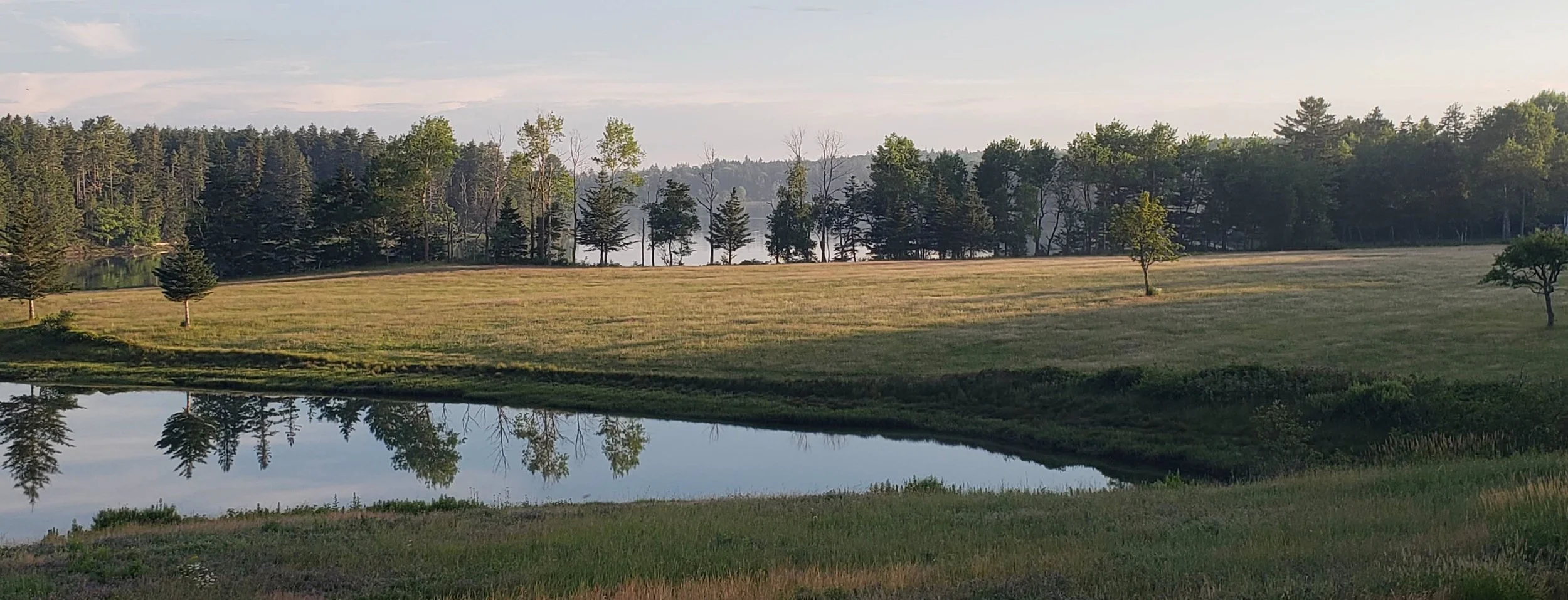
The St. George River itself rises near Montville in the hills of Waldo County and flows roughly 50 miles south through a chain of lakes and wetlands — including Lake St. George, Seven Tree Pond, and Crawford Pond — before reaching its tidal estuary at Thomaston and opening to the sea on the storied St. George Peninsula. Its watershed drains approximately 350 square miles of forest, farmland, wetland, and village, emptying ultimately into the Gulf of Maine.
Thousands of Years of Human Life
The first people arrived in what is now Maine not long after the glaciers withdrew — perhaps 12,000 to 13,000 years ago — following the retreating ice edge into a landscape of tundra, meltwater lakes, and abundant game. These Paleo-Indian peoples were the ancestors of the Wabanaki nations, and their descendants have maintained a continuous relationship with this landscape ever since.
Over thousands of years, that relationship deepened and elaborated. The Archaic and Woodland periods saw increasingly settled patterns of life along the river: seasonal camps at fish runs, shellfish harvests along the coast, burial sites, trade networks, and a rich material and ceremonial culture tied closely to the rhythms of the watershed. Salmon, eels, and alewives ran the river in numbers difficult to imagine today. The forests provided deer, moose, beaver, and bear. The marsh edges gave cattail, berries, and medicinal plants. The Wawenock people knew this place in a completeness that no map has ever captured.
European contact came in 1605, when English captain George Weymouth sailed his vessel into the river mouth and, in a moment that darkened what might have been a peaceful encounter, seized five Wawenock people and took them back to England. The river has carried his name ever since. English settlement followed fitfully through the 1700s — interrupted by wars and conflict with Wabanaki peoples defending their territory — and by the early 19th century the watershed had been transformed: forests cleared, mills built at every fall, and the distinctive lime industry of Knox County underway, fueled by the region's abundant limestone bedrock.
The Watershed Today
The St. George River watershed today is home to roughly 35,000 people living in a collection of towns that reflect the full range of Maine's Midcoast character. From the farming communities of the upper watershed — Montville, Liberty, Searsmont, Appleton, and Washington — to the mill and village towns of the middle river — Union and Warren — to the working waterfront communities of the lower watershed and peninsula — Thomaston, Cushing, South Thomaston, and St. George — the watershed is a landscape of remarkable variety. It is farmed and fished, hiked and paddled, painted and written about. It is, in the fullest sense, a living place.
The Georges River Land Trust
Since its founding, the Georges River Land Trust has worked to ensure this landscape remains wild, connected, and accessible for the people and wildlife that depend on it. The Land Trust's mission states it plainly:
"Conserve and care for the diverse ecosystems and wildlife habitats of the St. George River watershed, expand access to nature for all people, and collaborate with partners through education and the arts to inspire lasting kinship with the natural world."
Through conservation easements, land acquisition, stewardship, and community partnership, the Land Trust protects the working farms, forested ridges, wetland corridors, and riverside habitats that make this watershed what it is. Every acre protected is a decision made on behalf of the brook trout in the headwaters, the osprey on the river bend, and the children who haven't yet had the chance to discover this place.
The Maine Council of Trout Unlimited
Trout Unlimited Maine is the state council of Trout Unlimited, America's oldest and largest cold-water conservation organization. In Maine, TU chapters work to protect and restore the brook trout streams, landlocked salmon lakes, and wild Atlantic salmon rivers that define the state's watersheds. Their work includes stream habitat improvement, dam removal advocacy, riparian buffer protection, and water quality monitoring — often in direct partnership with land trusts, state agencies, and tribal communities. Maine holds the largest remaining wild brook trout population in the eastern United States, and TU Maine's mission is to keep it that way. Learn more at tumaine.org.
An Invitation
This blog series — The Living River — is an invitation to meet your neighbors. Not the ones on your street, but the ones in the marsh, under the ice, in the canopy overhead, and in the leaf litter at your feet: the beaver and the otter, the trout lily and the cattail, the whirligig beetle and the American eel. Each week we'll introduce one species from the St. George River watershed — its life, its role, its story, and its place in the long human relationship with this land.
The watershed is not a backdrop. It is a community, ancient and intricate, and we are part of it. We hope these stories remind you of that — and send you outside to look.
Want to Learn More?
- Georges River Land Trust — Conservation news, protected lands, events, and ways to get involved.
- Maine Geological Survey — Glacial History — An accessible overview of how Maine's landscape was shaped by glaciation.
- Wabanaki Confederacy and History — Abbe Museum — A leading institution for Wabanaki art, history, and culture, located in Bar Harbor.
- Maine Memory Network — St. George River History — Digitized historic photographs, documents, and maps from communities throughout the watershed.
- Native Plant Trust: Go Botany — An essential field companion for identifying the plants you'll encounter along the river.
The Living River blog series is published by St. George Consulting in support of the Georges River Land Trust and the Maine Council of Trout Unlimited. To explore the important work these organizations are doing to conserve and restore Maine's landscapes, visit georgesriver.org and tumaine.org.
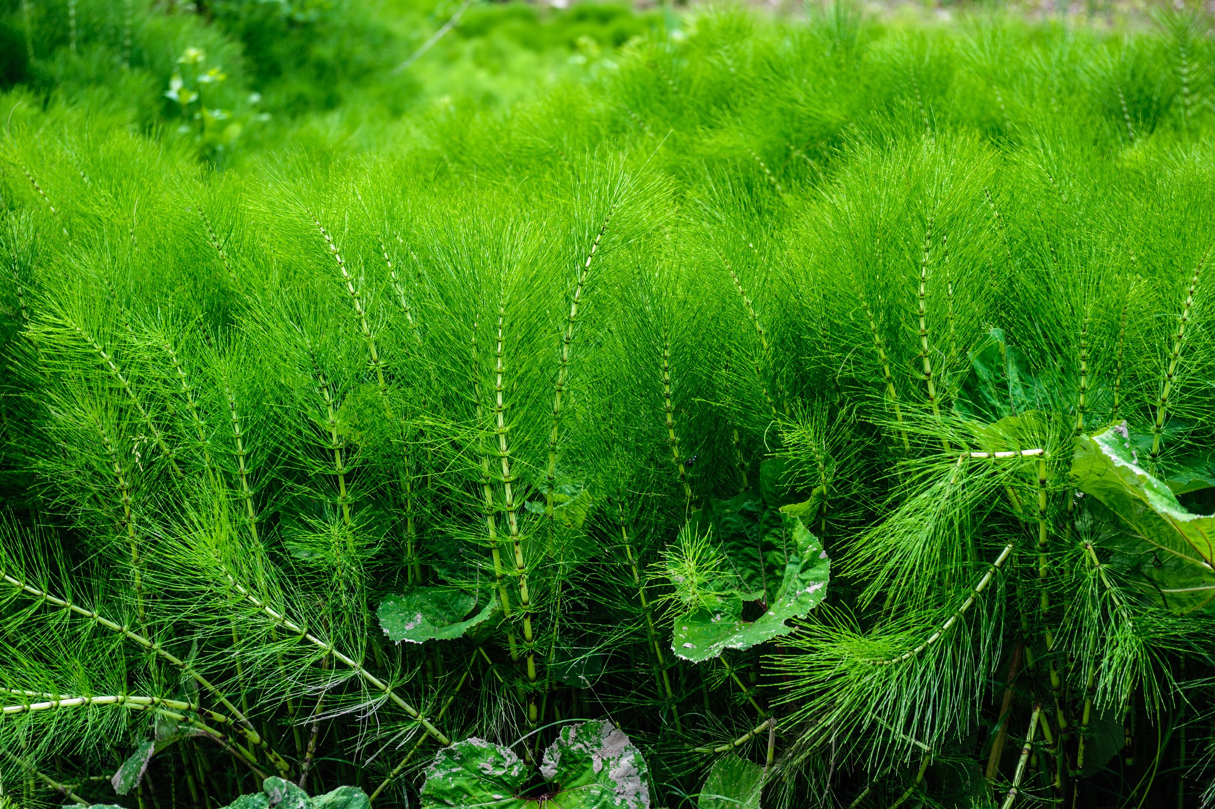
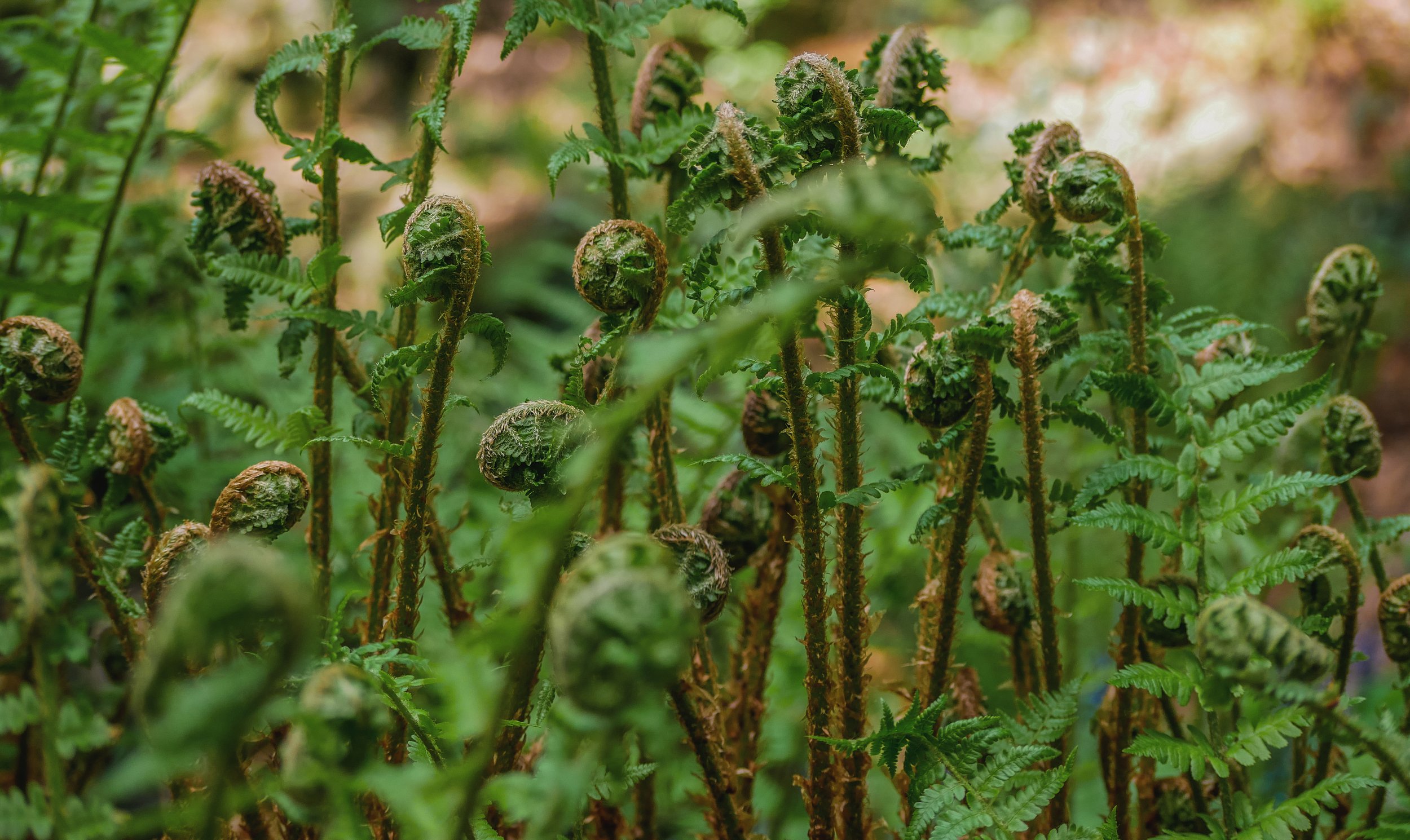
Horsetail
Pull on your rubber boots and walk the muddy margin where the St. George River meets a quiet marsh, and you will almost certainly encounter a plant that was standing in wet soil at water's edge three hundred and fifty million years ago. Horsetail is one of the oldest living plant lineages on Earth — and it is quietly remarkable.
Before the Dinosaurs: Horsetail on the Banks of the St. George
Georges River Land Trust — Living River Species Series
Introduction
Pull on your rubber boots and walk the muddy margin where the St. George River meets a quiet marsh or wooded wetland edge, and you will almost certainly encounter a plant that was doing exactly this — standing in wet soil at water's edge — three hundred and fifty million years ago. Horsetail (Equisetum spp.) is one of the oldest living plant lineages on Earth. It watched the dinosaurs come and go. It is still here, jointed and green and quietly remarkable, looking much as it always has. For a plant that has seen so much, it is surprisingly easy to overlook.
Natural History
Equisetum is the sole surviving genus of an entire class of plants that once formed Carboniferous forests — some species growing forty feet tall, their compressed remains now part of the coal seams beneath our feet. Today's horsetails are modest by comparison, rarely exceeding three or four feet, but they carry the same essential architecture: hollow, jointed stems ringed at each node with whorls of slender branches. Run your finger along the stem and you feel a faint roughness — that is silica, deposited in the cell walls in quantities high enough that colonists once bundled the stems to scrub pots and smooth wood. Scouring rush (E. hyemale) earned its name honestly.
Several Equisetum species inhabit the St. George watershed. Water horsetail (E. fluviatile) grows directly in shallow water and marsh edges. Field horsetail (E. arvense) colonizes stream banks and disturbed wet soils. Scouring rush (E. hyemale) forms dense clumps in moist woods and stream margins, its unbranched stems persisting green well into winter.
These are not flowering plants. Equisetum reproduces by spores, released in spring from cone-like structures at the tips of fertile stems — a reproductive strategy unchanged since long before flowers existed. The spores are equipped with hygroscopic bands that coil and uncoil with changes in humidity, helping to disperse them on the wind.
Role in the St. George River Watershed
In the watershed's wetland margins, horsetails function as structural habitat — dense, persistent stands that provide cover, perching sites, and physical complexity in places where other vegetation is sparse or seasonally absent.
Dragonflies and damselflies use horsetail stems as emergence scaffolding in late spring and early summer, crawling up out of the water to split their nymphal cases and expand their wings. The stems are also favored perching sites for hunting adults — you are likely to find both species resting on horsetail on any warm July afternoon at the water's edge.
Wood frogs and spring peepers shelter in the dense base of horsetail stands during breeding season, and the stems provide cover for painted turtles navigating between basking sites and water. Muskrats feed on horsetail rhizomes through late summer and fall, digging through soft mud to reach the underground stems. Canada geese and wood ducks browse the tender young shoots in early spring.
Because horsetail rhizomes form deep, interconnected networks, the plants are effective bank stabilizers — holding saturated stream-margin soils in place during high water and protecting the clear, cool water conditions that brook trout, caddisfly larvae, and freshwater mussels depend on downstream.
Seasonal Notes
Equisetum is among the first plants to show green in the watershed, with fertile shoots of field horsetail emerging as early as late March — sometimes while frost still hardens the ground at night. Vegetative stems follow through April and May, deepening to rich green through summer. Scouring rush holds its color through November and into December, one of the few native plants still green at the river's edge after hard frost. A stand of horsetail in January, stiff and pale but upright, is worth a second look.
Fun Fact
The ancient forests dominated by giant horsetails collapsed and compressed over millions of years into the coal beds that fueled the Industrial Revolution. When you burn coal, you are, in a very literal sense, burning the compressed remains of Equisetum's ancestors. The plant standing at the edge of your favorite fishing pool is the last living branch of a lineage that once powered much of the modern world.
Want to Learn More?
- USDA Plants Database — Equisetum — Distribution maps and species profiles for all North American horsetail species.
- iNaturalist — Horsetails in Maine — Community sightings and photographs from New England observers.
- University of Maine Cooperative Extension — Wetland Plants — Identification and ecology of common Maine wetland plants.
- Paleobotany of Horsetails — University of California Museum of Paleontology — The deep history of the Equisetum lineage and its ancient relatives.
The Living River blog series is published by St. George Consulting in support of the Georges River Land Trust and the Maine Council of Trout Unlimited. To explore the important work these organizations are doing to conserve and restore Maine's landscapes, visit georgesriver.org and tumaine.org.

Painted Turtle
On any warm spring day along the St. George River, move quietly and scan the logs: painted turtles, lined up in a row, soaking in the sun with an air of complete contentment. The most widespread native turtle in North America, the painted turtle has been doing exactly this along Maine's waterways for millions of years. It is a living artifact.

Sun, Shell, and Stillwater: The Painted Turtle
St. George Consulting — Living River Series
Introduction
On any warm spring day along the St. George River, if you move quietly and scan the logs and rocks along the water's edge, you are likely to find them: painted turtles (Chrysemys picta), lined up in a row with their necks stretched long and their legs splayed wide, soaking in the sun with an air of complete contentment. They are among the most familiar reptiles in the Northeast, and yet there is something endlessly pleasing about spotting them — a reminder that this small, sun-warmed creature has been doing exactly this along Maine's waterways for millions of years. The painted turtle is a living artifact, and the St. George watershed is lucky to have them.
Natural History
The painted turtle is the most widespread native turtle in North America, found from the Atlantic coast to the Pacific Northwest. Maine sits near the northern edge of its range, which makes our turtles particularly remarkable — they endure winters that would seem impossibly harsh for a cold-blooded animal.
They are beautifully marked: a dark olive or black shell edged in red and yellow, a yellow-striped neck and head, and the vivid red-and-yellow patterning along the shell's margins that gives them their name. Adults are typically five to seven inches long, with females running slightly larger than males.
Painted turtles are omnivores, eating aquatic plants, algae, insects, crayfish, snails, small fish, and carrion — whatever the pond or slow river offers. They are almost entirely aquatic, leaving the water mainly to bask and, in June, for females to lay eggs. Nesting females wander surprisingly far from water in search of sunny, sandy or loose-soiled sites, often crossing roads in the process — one of their most serious modern hazards.
Eggs hatch in late summer, but here is where Maine's painted turtles reveal their extraordinary cold-hardiness: hatchlings often overwinter in the nest, surviving temperatures that dip below freezing by producing a natural antifreeze — glucose that floods their tissues and prevents ice crystals from forming inside their cells. They emerge in spring as if nothing unusual happened.
Role in the St. George River Watershed
Painted turtles are quiet but meaningful participants in the watershed's ecology.
As omnivores, they help regulate aquatic invertebrate populations — snails, aquatic insects, and small crustaceans — while also consuming carrion and plant material, making them modest but real contributors to nutrient cycling in ponds and slow river reaches. Think of them as generalist cleaners of the aquatic environment.
Their basking logs and rocks are shared real estate. You'll often find painted turtles sunning alongside map turtles (less common here) and occasionally snapping turtles, whose relationship with painted turtles is more fraught — snapping turtles will prey on painted turtle eggs and hatchlings given the opportunity.
Raccoons, skunks, and foxes are the primary predators of painted turtle nests, and nest predation rates can be extremely high — in some populations, the majority of nests are destroyed each year. The turtles offset this by living a long time: a painted turtle can live 35 to 40 years, giving it many seasons of reproductive effort. Mink and great blue herons occasionally take hatchlings and juveniles near the water's edge.
The aquatic plants of the watershed — pondweeds, water lilies, and algae — are both food and cover for painted turtles, and the slow, weedy backwaters and pond margins they favor are the same habitats that support dragonflies, damselflies, and freshwater mussels. A healthy painted turtle population is a good indicator that these quieter, less-noticed corners of the watershed are intact.
Seasonal Notes
Painted turtles emerge from hibernation in April, often while ice still lingers on shaded pond edges. Basking peaks in May and June, when the animals need to warm themselves after winter and females are building energy for egg production. Nesting happens in June, typically on south-facing, open ground — roadsides, gravel shoulders, and garden beds are common sites, which puts females in harm's way. Hatchlings appear in August and September and may overwinter in the nest, emerging the following April. By October, adults have returned to the pond bottom to hibernate in the mud.
Fun Fact
In painted turtles — and several other turtle species — the temperature of the nest determines the sex of the hatchlings. Warmer nests produce mostly females; cooler nests produce mostly males. This means that climate change, which is warming soils across the Northeast, may be quietly skewing turtle populations toward females over time. Researchers are actively studying what this means for the long-term health of turtle populations.
Want to Learn More?
- Maine IF&W — Reptiles and Amphibians — Maine's wildlife agency overview of native turtle species and their status.
- Maine Audubon — Turtle Road Mortality — Information on the serious threat road crossings pose to nesting turtles, and how to help.
- Maine Herpetological Society — A great resource for learning more about Maine's reptiles and amphibians.
- iNaturalist — Painted Turtle — Observe sightings across the region and contribute your own.
The Living River blog series is published by St. George Consulting in support of the Georges River Land Trust and the Maine Council of Trout Unlimited. To explore the important work these organizations are doing to conserve and restore Maine's landscapes, visit georgesriver.org and tumaine.org.
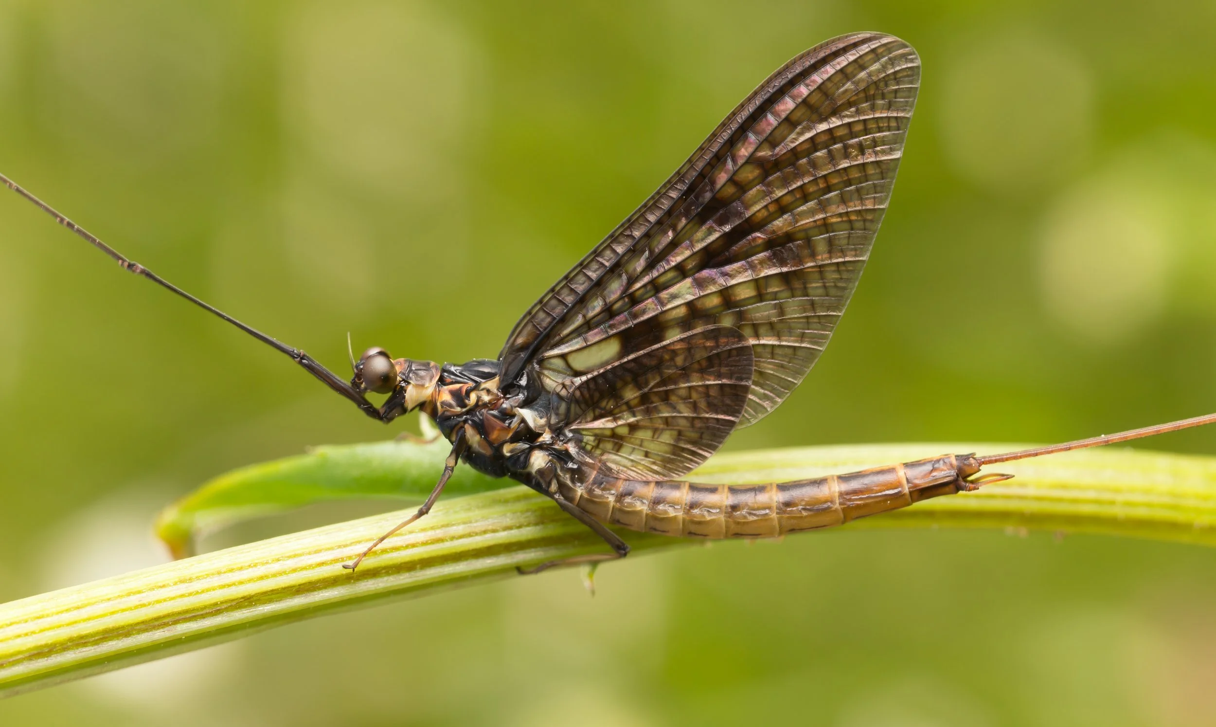
Mayflies
On a warm May evening, you might notice something that looks like a light snowfall rising from the St. George River — thousands of delicate winged insects drifting upward in spiraling columns. If you're a fly fisher, your heart quickens. If you're a brook trout, you're already moving. Mayflies have been doing this for 350 million years.

Born in the River, Gone in a Day: The Mayfly
St. George Consulting — Living River Series
A Life Measured in Hours
On a warm May evening along the St. George River, you might notice something that looks like a light snowfall rising from the water — thousands of delicate winged insects drifting upward in spiraling columns, catching the last of the day's light. If you're a fly fisher, your heart quickens. If you're a brook trout, you're already moving. If you're a curious passerby, you've just witnessed one of the most remarkable events in the river's calendar: a mayfly hatch.
Mayflies have been doing this for roughly 350 million years, making them one of the oldest groups of winged insects on Earth. What they accomplish in a few hours of adult life — after spending nearly a year underwater — is a small miracle worth stopping to watch.
Natural History: Mostly Water, Briefly Sky
Mayflies belong to the order Ephemeroptera, from the Greek word for "lasting a day" — a fitting name for animals whose adult lives are measured in hours. But that brief finale is only the final act of a much longer story.
After eggs hatch, mayfly nymphs spend most of their lives — several months to nearly two years, depending on species — living on the streambed. They breathe through feathery gills, cling to rocks and submerged debris, and feed on algae, diatoms, and fine organic matter. During this time they molt repeatedly, sometimes 20 times or more, growing gradually toward adulthood.
When the time comes, the nymph rises through the water column and splits its skin at the surface, emerging as a winged but not-quite-adult form called a subimago — what fly fishers call a "dun." This stage lasts anywhere from a few minutes to a day. Then comes something unique in the insect world: the subimago molts one final time, shedding its skin to become the true adult, or imago (known to anglers as a "spinner"). Mayflies are the only insects on Earth that molt after they already have wings.
The adult has no functional mouthparts. It will never eat. Fueled entirely by energy stored during its long nymph stage, it has one purpose: find a mate, lay eggs on the water, and complete the cycle. Most adult mayflies live less than 24 hours. A few species survive only 90 minutes.
Role in the St. George River Watershed
Few creatures are more important to the St. George's food web than the mayfly. Nymphs are a year-round staple for brook trout, brown trout, and many other fish throughout the watershed. Emerging adults feed swallows, flycatchers, bats, and kingfishers. Even the spent adults that fall onto the water surface after mating — what anglers call "spinners" — provide another feeding opportunity for fish rising at dusk.
Mayflies are also one of the best indicators of river health that exist. Along with stoneflies and caddisflies, they form what biologists call the EPT index — a standard measure of river water quality. Healthy mayfly populations mean clean, well-oxygenated water. Their absence from a stretch of river is a warning sign worth investigating.
The St. George River is known among fly fishers for its red quill hatch in May — a reliable emergence of one of the most important mayfly species in the Northeast. The stretch below Sennebec Pond can fish beautifully during this hatch, with trout rising actively in the evening hours.
Seasonal Notes
Mayfly hatches on the St. George begin in mid-May and continue through June, with different species emerging in sequence. Some extend into summer and early fall. The most dramatic hatches happen on calm, overcast evenings when water temperatures are right — conditions that concentrate the emergence and send every trout in the river looking up.
Even if you're not fishing, an evening hatch is worth seeking out.
Fun Fact
Mayflies are the only insects in the world that molt after they already have functional wings. Every other winged insect reaches its final form at the moment it first grows wings. The mayfly takes one more step — shedding that intermediate winged stage to become its true adult self. Scientists consider this an ancient trait, a living window into the very origins of insect flight.
Learn More
- Maine DEP — Biomonitoring: Mayflies
- Maine IFW — Rare Mayflies
- All About Birds — Mayfly (aquatic insect overview)
- The Freshwater Blog — The Mayfly's Lifecycle
- Northern Woodlands — Outside Story (search "mayfly")
- EPT Index and Stream Health — The Swamp School
The Living River blog series is published by St. George Consulting in support of the Georges River Land Trust and the Maine Council of Trout Unlimited. To explore the important work these organizations are doing to conserve and restore Maine's landscapes, visit georgesriver.org and tumaine.org.
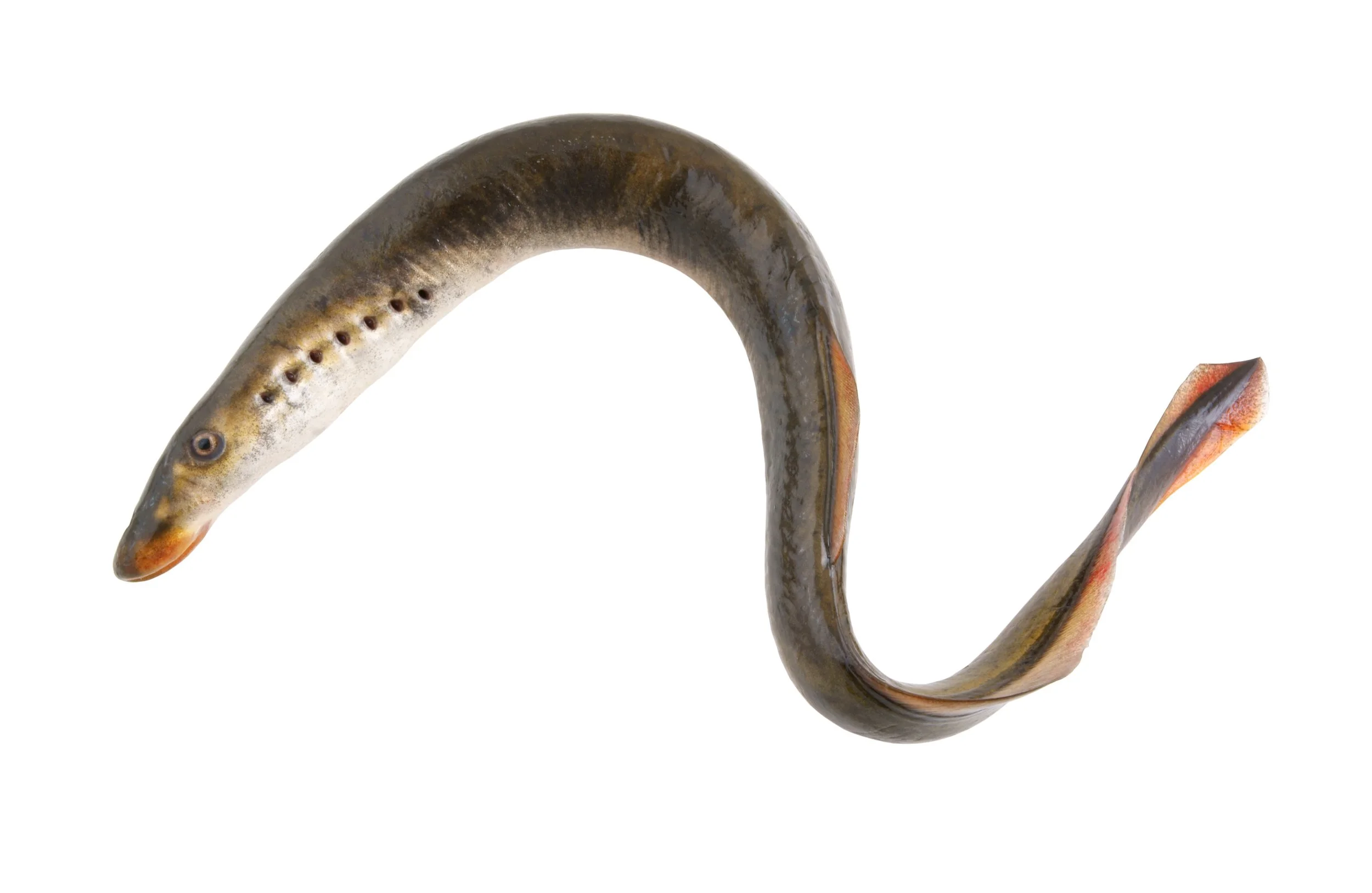
Sea Lamprey
The sea lamprey has an image problem. Most people picture the invasive pest of the Great Lakes — not the native fish that has been swimming Maine's rivers for 360 million years, predating the Atlantic Ocean itself. In the St. George watershed, lamprey are ecological partners, building gravel nests that salmon and trout also depend on. It deserves a second look.

Older Than the Atlantic: The Sea Lamprey of the St. George
St. George Consulting — Living River Series
Give It a Second Chance
The sea lamprey has an image problem. Most people picture the invasive pest that devastated Great Lakes fisheries in the twentieth century — a toothy, eel-like creature with a sucker mouth that sounds more like a horror film prop than a wild neighbor worth appreciating. But in Maine, the sea lamprey is something entirely different: a native fish, a river builder, and one of the most ancient vertebrates on Earth. It deserves a second look.
Natural History: 360 Million Years and Counting
The sea lamprey (Petromyzon marinus) belongs to a lineage that has been swimming in the world's waters for roughly 360 million years — predating the dinosaurs, the Atlantic Ocean itself, and most of the plant life we think of as ancient. It is one of the last surviving jawless vertebrates, a group that once dominated the seas before fish with jaws appeared and changed everything. The lamprey's basic design has barely changed since.
Its life cycle is among the more remarkable in the river world. Adults spawn in late spring and early summer, moving rocks with their sucker mouths to build gravel nests in clean, flowing water. A single female deposits over 100,000 eggs, and shortly after spawning, both parents die — their bodies a pulse of nutrients for the stream.
The larvae — called ammocoetes — are blind and look nothing like their parents. They burrow into soft streambed sediment and spend the next four to six years filter-feeding on algae and organic particles, invisible to most passersby. Then comes a dramatic metamorphosis: eyes develop, the toothed oral disk forms, and the young lamprey migrates to the sea.
In salt water, it spends one to two years as a parasite, attaching to host fish and feeding on blood and tissue. Then, following some ancient internal signal, it stops feeding, returns to freshwater, spawns, and dies. The whole cycle takes roughly seven years.
Role in the St. George River Watershed
In Maine, sea lamprey are native and ecologically important — a fact lost in the understandable alarm over their Great Lakes invasion. Here, they evolved alongside Atlantic salmon, alewives, and shad over millions of years.
Their nest-building is genuinely valuable: as spawning adults move rocks with their mouths, they loosen compacted sediment and create clean, well-oxygenated gravel that Atlantic salmon and brook trout also depend on for spawning. They are, in the language of ecologists, habitat engineers.
Their post-spawning die-off matters too. Spent carcasses enrich the stream with marine-derived nutrients — phosphorus, nitrogen, organic matter — fertilizing the invertebrate communities that fish depend on.
Like so many native sea-run species, lamprey populations in Maine have declined due to dams blocking spawning migrations. Restoring fish passage on the St. George and its tributaries benefits lamprey as much as salmon and shad.
The Wabanaki and the Lamprey
For the Wabanaki peoples who have lived in and traveled these watersheds since long before European contact, sea lamprey were part of the spring river bounty. The Mi'kmaq people are documented as having eaten sea lamprey, and lamprey featured in the food traditions of Indigenous peoples across the Northeast.
The appeal was nutritional as well as cultural. Lamprey are exceptionally rich in fat and calories — more so than salmon — making them a prized food, especially after lean winter months. They were harvested during spring spawning runs, smoked for preservation, and their oil was valued for food and medicine. The lamprey's predictable spring arrival, alongside alewives and salmon, was part of the seasonal river rhythm that sustained Wabanaki communities for millennia.
Seasonal Notes
Sea lampreys enter St. George River tributaries in late May and June to spawn. Look for the characteristic circular nest depressions — called redds, like those of salmon — in shallow gravel riffles. The adults are distinctive: gray-brown, eel-shaped, one to two feet long, with a round, jawless mouth.
Fun Fact
Sea lampreys have no jaw, no scales, and no bones — their skeleton is cartilage throughout. They have seven gill openings on each side of the body, giving them an otherworldly, polka-dotted look. And they navigate by smell, homing on the precise chemical signature of the stream where they hatched.
Learn More
- Maine DMR — Sea Lamprey
- NRCM Creature Feature — Sea Lamprey
- NRCM — Sea Lamprey Migration in the Sheepscot River
- US Fish & Wildlife Service — Sea Lamprey
- Traditional Animal Foods of Indigenous Peoples — Lampreys
The Living River blog series is published by St. George Consulting in support of the Georges River Land Trust and the Maine Council of Trout Unlimited. To explore the important work these organizations are doing to conserve and restore Maine's landscapes, visit georgesriver.org and tumaine.org.
Fiddleheads
In Midcoast Maine, fiddlehead season is fast and fleeting — typically the last week of April through mid-May, depending on the year. Watch the riverbanks once the daytime temperatures consistently reach the 50s. Within a week or two of emerging, the coils unfurl and the season is over until next spring.
Fiddleheads: The St. George River's Springtime Scrollwork
St. George Consulting — Living River Series
Intro
Walk along the banks of the St. George River in late April, and you may find yourself face to face with one of Maine's most beloved springtime greetings: tightly coiled, jewel-green spirals pushing up through last year's leaf litter. These are fiddleheads — the young, unfurling fronds of the ostrich fern (Matteuccia struthiopteris) — and for a few short weeks they transform our floodplain forests into something that looks almost enchanted. Part vegetable, part sculpture, part calendar, fiddleheads are a quiet announcement that the cold has loosened its grip on the watershed.
A Little Natural History
The ostrich fern is a perennial that lives quietly underground for most of the year, surviving as a tough, woody crown anchored in rich, moist soil. Each spring, that crown sends up a cluster of new fronds, each one tightly rolled into the curl that gives fiddleheads their name — a shape so reminiscent of the carved scroll on a violin that the resemblance has stuck for centuries.
A fiddlehead is most recognizable by three signs: a deep U-shaped groove running along the inside of its smooth stem, a papery brown husk that flakes off easily, and that signature tight coil. As the fronds mature, they unfurl into the elegant, vase-shaped plumes that give the plant its name (the fronds are said to resemble ostrich feathers). A mature ostrich fern colony can be remarkably long-lived — some clones are believed to persist for a century or more, slowly spreading via underground rhizomes.
Role in the St. George River Watershed
Fiddleheads aren't just a seasonal treat — they're an indicator and a worker. Ostrich ferns thrive in alluvial soils: the rich, periodically flooded ground along streams, oxbows, and river terraces. In the St. George watershed, you'll find them in the silver maple and red maple floodplain forests that line stretches of the river from Searsmont down through Warren and Thomaston.
These fern colonies do real ecological work. Their dense rhizome mats help stabilize riverbanks during high water, slowing erosion and trapping sediment. The shaded, humid microclimate beneath their fronds supports salamanders, ground beetles, and a quiet understory of spring ephemerals. Healthy fiddlehead populations are a good sign that a riparian zone is intact — and a warning, when they vanish, that something has changed: invasive plants, altered hydrology, or overharvest.
Wabanaki Knowledge and Use
Long before fiddleheads were trendy farmers' market fare, they were a vital spring food for the Wabanaki peoples — the Penobscot, Passamaquoddy, Maliseet, Mi'kmaq, and Abenaki nations whose homelands include the St. George River watershed. After a long winter of dried, smoked, and stored foods, the arrival of fresh green fiddleheads was a genuine nutritional turning point, rich in vitamins A and C, iron, and antioxidants.
Wabanaki harvesters traditionally gathered fiddleheads from the same family-tended patches year after year, taking only a portion from each crown so the plant could continue to thrive — a model of stewardship that modern foragers would do well to follow. The fronds were eaten fresh-cooked, and sometimes preserved by drying for later use. Today, Wabanaki communities continue to harvest fiddleheads as a living cultural practice, and several tribal food sovereignty programs work to protect access to traditional gathering grounds.
If you forage, please follow their lead: take no more than half the fronds from any single crown, never harvest from sensitive or posted lands, and always cook fiddleheads thoroughly — boil for at least 10 minutes or steam for 15. Raw or undercooked fiddleheads can cause serious stomach upset.
Seasonal Notes
In Midcoast Maine, fiddlehead season is fast and fleeting — typically the last week of April through mid-May, depending on the year. Watch the riverbanks once the daytime temperatures consistently reach the 50s. Within a week or two of emerging, the coils unfurl and the season is over until next spring.
Fun Fact
A single ostrich fern crown can produce fronds for over 100 years. The patch you find this spring may have been greeting the river — and the people who love it — since before the Civil War.
Further Reading
- University of Maine Cooperative Extension: Facts on Fiddleheads
- Maine Department of Agriculture: Safe Handling of Fiddleheads
- Wabanaki Cultural Heritage — Abbe Museum
- Native Plant Trust: Matteuccia struthiopteris profile
- Georges River Land Trust
The Living River blog series is published by St. George Consulting in support of the Georges River Land Trust and the Maine Council of Trout Unlimited. To explore the important work these organizations are doing to conserve and restore Maine's landscapes, visit georgesriver.org and tumaine.org.
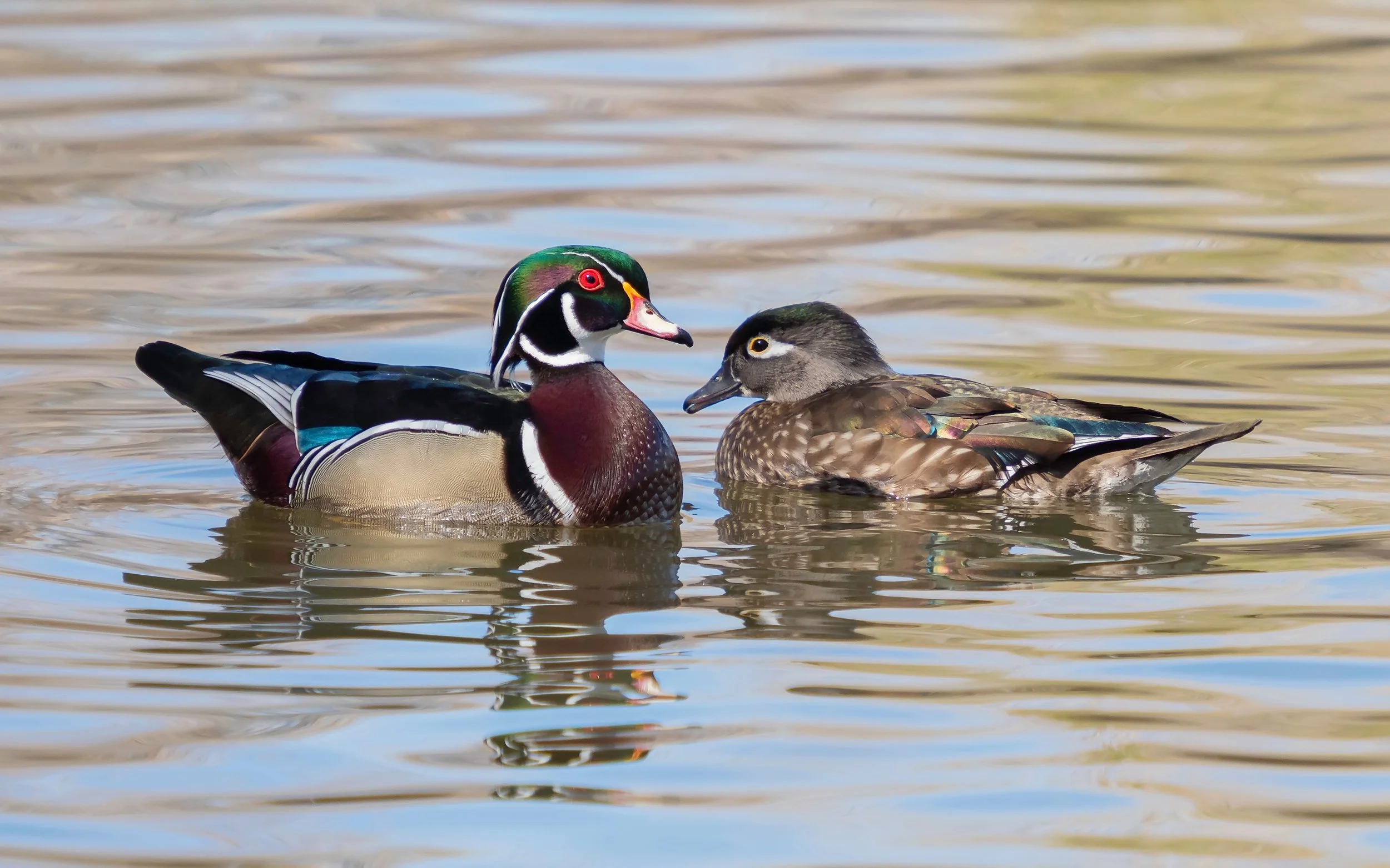
Wood Duck
It is a reasonable argument that the male wood duck is the most beautiful bird in North America. A bird of the beaver pond and forested wetland, the wood duck nests in hollow trees along the St. George watershed — and within 24 hours of hatching, its ducklings must climb to the entrance and jump, sometimes 50 feet to the forest floor. They shake it off.

The Leap of Faith: The Wood Duck
St. George Consulting — Living River Series
Introduction
It is a reasonable argument that the male wood duck (Aix sponsa) is the most beautiful bird in North America. An iridescent green and purple crested head traced with white lines, a chestnut breast, warm tan flanks, a vivid red eye and red-tipped bill — the description sounds overdone until you see one gliding out of the shadowed edge of a beaver pond into a shaft of morning light, and then it seems barely adequate. Wood ducks are birds of the forested wetland, and the swampy backwaters, flooded woodland edges, and quiet pond margins of the St. George watershed are precisely the habitat they have shaped their lives around. They are here every summer, raising families in hollow trees, and their presence is one of the quieter joys the watershed extends to those paying attention.
Natural History
Wood ducks are medium-sized, compact ducks with a distinctive large head and a squared-off tail they hold cocked upward in flight. The male's plumage in breeding season is so elaborate it appears almost artificial. The female is subtler but striking in her own right — soft gray-brown with a bold white teardrop ring around the eye that makes her instantly identifiable, even in poor light.
They are cavity nesters, dependent on large hollow trees near water, and this dependence shaped both their near-extinction and their recovery. By 1900, a combination of unrestricted market hunting and the wholesale clearing of the old forests that provided nesting cavities had pushed wood ducks toward collapse. They were considered one of the most endangered waterfowl in North America. The Migratory Bird Treaty Act of 1918 halted the hunting, and the subsequent explosion of nest box programs — wooden boxes designed to mimic natural cavities, mounted on posts over water — did the rest. It is one of the most complete wildlife recoveries on record, driven almost entirely by habitat provision and harvest management.
Wood ducks eat a broad diet: acorns, wild grapes, berries, seeds of aquatic plants, aquatic insects, beetles, and invertebrates. The acorn is the centerpiece of their autumn diet, and their consumption and occasional dropping of acorns makes them modest but real dispersers of oak trees throughout the forested wetland landscape.
Role in the St. George River Watershed
Few species in this series are as thoroughly embedded in the watershed's physical structure as the wood duck. Their preferred habitat — flooded woodland, beaver-created ponds, slow backwaters edged with old trees — is exactly the landscape that American beavers (another subject in this series) build and maintain. Wherever beavers have raised the water table and killed standing timber, wood ducks find nesting cavities, protective cover, and calm water for raising ducklings. The relationship is not direct — wood ducks and beavers don't interact — but the beaver reshapes the landscape in precisely the ways that most benefit the duck.
Raccoons are the primary predator of wood duck nests and eggs, which is why nest boxes mounted on smooth metal poles in the middle of water are so effective — raccoons can't reach them. Mink are a serious threat to broods in and near the water, and snapping turtles take ducklings from below — another connection in the network of species this series has explored. Barred owls take ducklings at night, and large largemouth bass are a documented predator of very young ducklings in weedy ponds.
As consumers of aquatic invertebrates, wood ducks connect to the dragonfly, damselfly, and aquatic beetle communities of the watershed's wetlands. As acorn eaters and occasional seed droppers, they participate in the slow dispersal of oak and other hardwood mast across the wetland landscape.
The great blue heron shares the same forested wetland habitat, and the two species often occupy the same beaver ponds simultaneously — the heron hunting the shallows while the wood duck feeds along the vegetated margins, their ecological needs different enough that they rarely interfere with each other.
Seasonal Notes
Wood ducks arrive in the St. George watershed in April, among the earlier returning waterfowl. Nesting begins almost immediately, with eggs laid through April and May. Ducklings appear in late May and June and grow rapidly, becoming capable of flight in roughly 60 days. By September and October, families have dispersed and birds begin moving south, though some linger into November in mild autumns. The richly colored males are most visible in April and early May before they molt into a drab eclipse plumage through summer, making them considerably harder to identify until fall feathers return.
Fun Fact
Within 24 hours of hatching, wood ducklings must make one of the most dramatic leaps in the animal kingdom. The female calls from the ground below the nest cavity — which may be 50 feet or more above the forest floor — and the ducklings, one by one, climb to the entrance and jump. They have no flight feathers. They are covered in down. They tumble through branches, bounce off roots, and land on the ground or in the water below, almost always unhurt. Their tiny bodies are so light and their down so shock-absorbing that the fall that would kill an adult bird is merely an inconvenience to a day-old duckling. They shake themselves off and follow their mother to the water.
Want to Learn More?
- Cornell Lab of Ornithology — Wood Duck — Species account with field marks, calls, range maps, and the full recovery story.
- Maine Audubon — Wood Duck Nest Boxes — How nest box programs work and how you can participate in Maine.
- Maine IF&W — Waterfowl — Wood duck management and population monitoring in Maine.
- Wood Duck Society — Dedicated to wood duck conservation and nest box programs; practical resources for landowners.
The Living River blog series is published by St. George Consulting in support of the Georges River Land Trust and the Maine Council of Trout Unlimited. To explore the important work these organizations are doing to conserve and restore Maine's landscapes, visit georgesriver.org and tumaine.org.

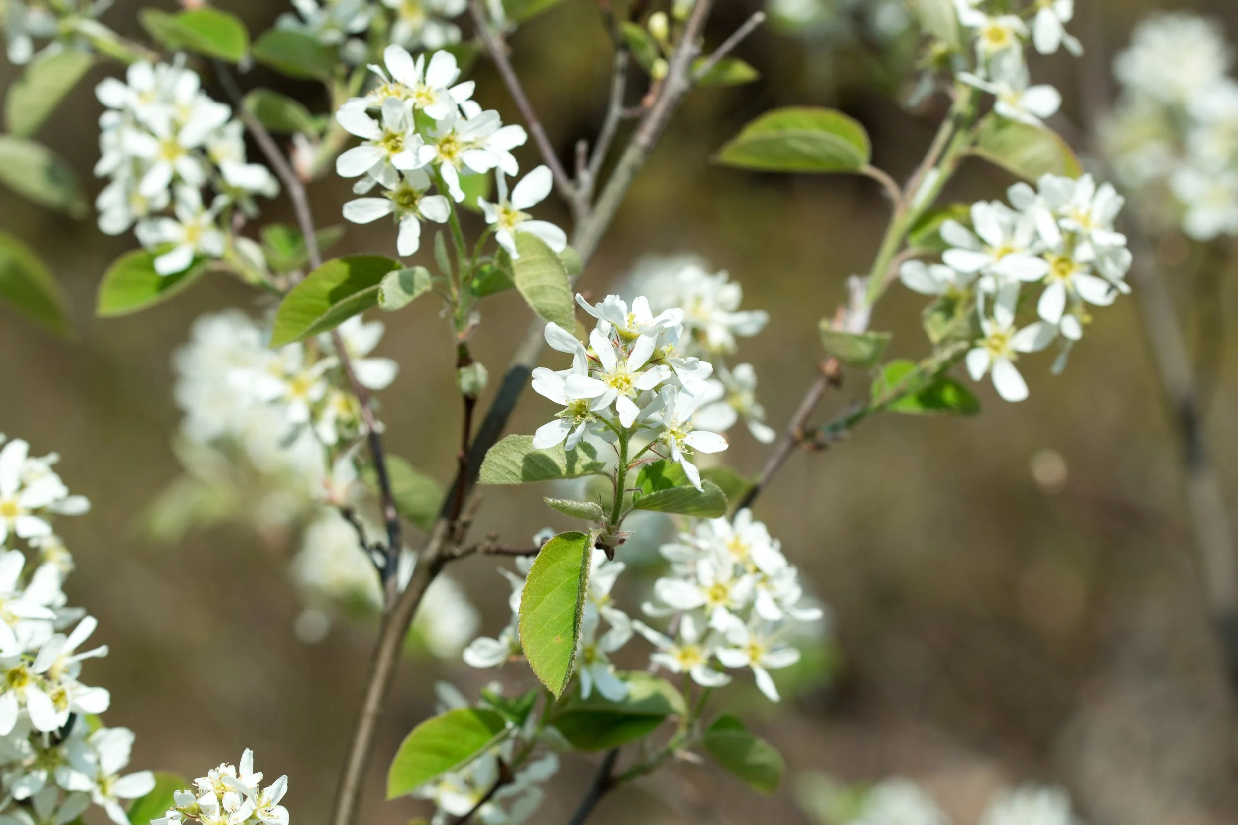
Flowering Shad
Every spring, before the leaves have opened and while the hillsides are still brown and bare, shadbush lights up in white — clusters of delicate, star-shaped blossoms catching the April light. It is easy to overlook in summer. But in April it stops you in your tracks, and its name ties it directly to the fish running below.
First Bloom, First Fruit: The Shadbush
St. George Consulting — Living River Series
Introduction
Every spring, before the leaves have opened and while the hillsides are still brown and bare, something remarkable happens along the edges of the St. George watershed. A small tree lights up in white — clusters of delicate, star-shaped blossoms catching the April light like scattered snow. This is Amelanchier, known here in Maine as shadbush or shadblow, and its bloom is one of the earliest and most welcome signs that winter has finally loosened its grip.
If you know where to look, shadbush is everywhere: rocky slopes, stream edges, forest margins, old fields growing back to shrub. It is easy to overlook in summer, but in April it stops you in your tracks.
Natural History
Several species of Amelanchier grow in Maine — A. canadensis, A. laevis, and others — and they are notoriously difficult to tell apart. In practice, most of us call them all shadbush and leave taxonomy to the botanists. What they share matters more than what separates them: white five-petaled flowers in early spring, small reddish-purple berries ripening by June, and a remarkable ability to thrive in the rocky, thin-soiled edges that define much of our coastal landscape.
Shadbush grows as a large shrub or small tree, typically 6 to 20 feet tall, often multi-stemmed and spreading. The leaves emerge slightly reddish and unfurl as the flowers fade. By midsummer the plant is unremarkable — a bit of green in the understory — but in June the berries arrive: small, sweet, and dark purple, clustered along the branches like tiny blueberries.
The name "shadbush" comes from a beautiful piece of ecological timing. The trees bloom just as the alewives and American shad begin running upstream to spawn — a reminder that in a living watershed, the calendar of one species is tied to the calendar of another.
Wabanaki Uses
For Wabanaki peoples, shadbush berries were an important and eagerly anticipated food. The sweet, early-ripening fruit was eaten fresh and also dried for winter use — pressed into cakes or mixed with dried meat and fat to make pemmican, a high-calorie food that sustained people through travel and lean seasons. The berries were sometimes dried over fire or in the sun and stored for months, retaining both nutrition and sweetness long after fresh fruit had disappeared.
The timing of the shadbush bloom and fruit was itself a form of knowledge — a signal woven into the seasonal calendar that told people when certain fish were running and when specific activities along the river were most productive. In Wabanaki understanding, the plant world and the animal world were in continuous conversation, and shadbush was one of its most reliable translators.
Role in the St. George River Watershed
In the watershed, shadbush punches well above its modest size. Its early bloom — often the first significant nectar source of the year — is a lifeline for native bees, queen bumblebees emerging hungry from hibernation, and early butterflies. In a landscape where few other plants are flowering, shadbush feeds the pollinators that will go on to serve the entire spring and summer growing season.
By June, the berries fuel a wave of hungry birds. Cedar waxwings descend in flocks. Baltimore orioles, rose-breasted grosbeaks, catbirds, and thrushes all seek out the fruit. The berries ripen and vanish quickly — often stripped within days — which means the window is narrow but the feast is real. White-tailed deer and black bears eat the fruit as well, and the dense, multi-stemmed structure of older shadbush provides good nesting cover for smaller songbirds.
Seasonal Notes
May is the moment — white flowers against bare gray branches, often visible from a distance. June and July bring the berries, ripening from pink to deep purple and disappearing fast. Summer is quiet; look for the smooth, oval leaves in the forest understory. Fall brings a quiet reward: shadbush foliage turns shades of orange, red, and gold — modest but warm, a small piece of the larger autumn display.
Fun Fact
Shadbush berries were historically sold in markets as "Juneberries" — a name still used in the Midwest, where Amelanchier species are native to open prairies. The fruit has a flavor reminiscent of blueberry with a hint of almond, from the seeds inside. Indigenous peoples across the continent prized these berries, and they are increasingly showing up at farmers' markets and specialty food producers who have rediscovered what the birds never forgot.
Want to Learn More?
- Native Plant Trust: Go Botany — Amelanchier — Species identification, range maps, and habitat notes for New England.
- USDA Plants Database — Amelanchier canadensis — Taxonomy, range, and ecological data.
- Maine Audubon — Planting for Birds: Native Shrubs — Guidance on native shrubs that support birds through the seasons.
- Abbe Museum — Wabanaki Cultural Connections — Resources on Wabanaki history, knowledge, and relationship with the natural world.
The Living River blog series is published by St. George Consulting in support of the Georges River Land Trust and the Maine Council of Trout Unlimited. To explore the important work these organizations are doing to conserve and restore Maine's landscapes, visit georgesriver.org and tumaine.org.

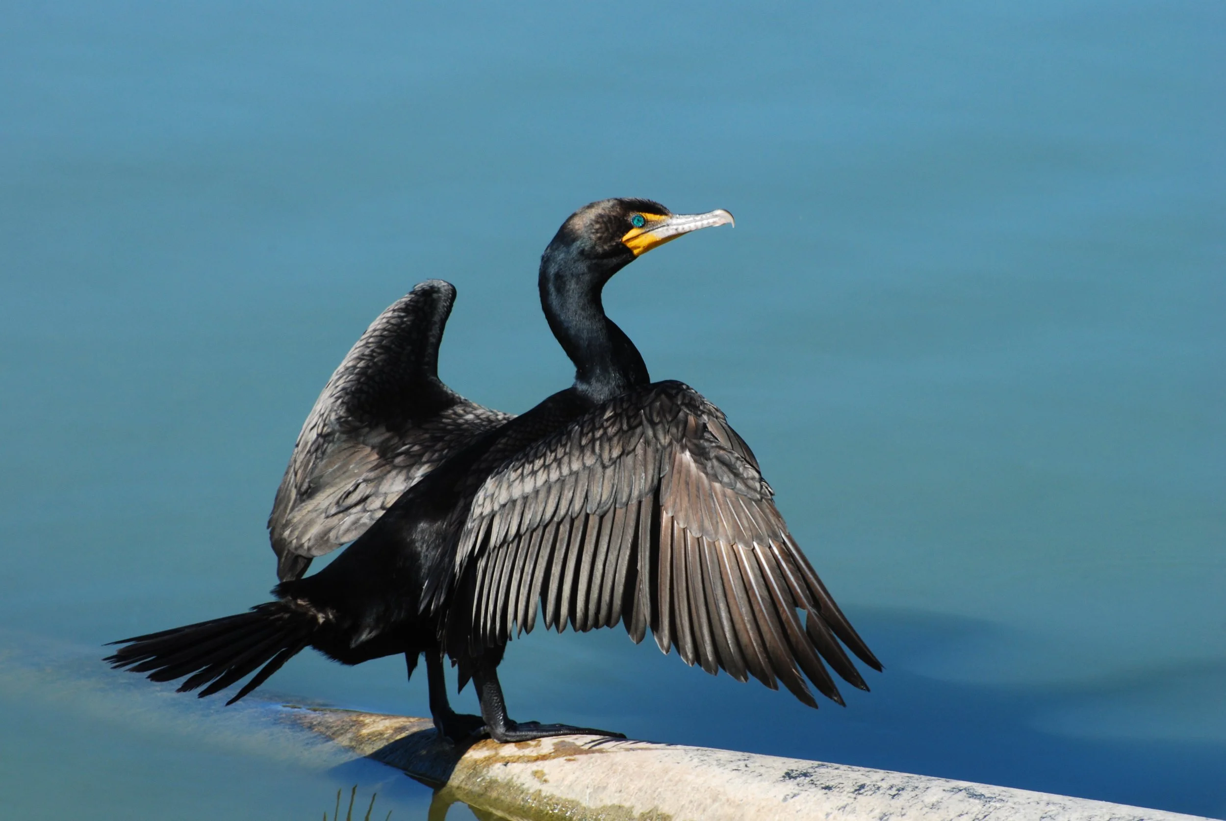
Double-crested Cormorant
The River's Black Diver: Double-crested Cormorant of the St. George
St. George Consulting — Living River Series
A Bird That Looks Like It Means Business
There's something almost prehistoric about a cormorant. Standing upright on a rocky ledge or a snag jutting from the river, wings spread wide to dry in the sun, it looks like a creature that has been doing this for a very long time — and it has. The double-crested cormorant (Nannopterum auritum) is one of North America's most successful waterbirds, and along the St. George River and its tidal reaches, it is a familiar and quietly impressive presence.
Not everyone loves the cormorant. It has a reputation for eating a lot of fish, which puts it at odds with some anglers. But spend a little time watching one — watching it surface dive with improbable grace, shake the water from its feathers, and tilt its bright orange-throated face toward the sky — and it's hard not to come around.
Natural History: Designed to Go Deep
The double-crested cormorant is a large, dark waterbird — roughly the size of a small goose — with black plumage that shimmers greenish in good light, a long neck built for chasing fish, and that distinctive orange-yellow throat pouch that's always visible. The "double crests" of the name are small tufts of white or dark feathers that appear briefly on adults during breeding season and are rarely conspicuous in the field.
Unlike ducks, cormorants have only partially waterproof feathers. This sounds like a design flaw, but it's actually an advantage: reduced buoyancy makes diving easier, and cormorants can pursue fish at depths that most diving birds can't reach. The trade-off is that they have to dry their feathers afterward — which explains that iconic spread-winged posture. When you see a cormorant standing like a small, dark gargoyle with its wings held out, it's doing exactly what it needs to do.
Underwater, cormorants are remarkably agile. They propel themselves with powerful webbed feet (their wings stay folded), using their hooked bill to snatch fish with precision. They can dive to 25 feet or more and stay submerged for up to a minute. Alewives, smelt, perch, minnows, and other small schooling fish make up the bulk of their diet.
Role in the St. George River Watershed
The cormorant's connection to the St. George watershed is especially vivid during the alewife run — one of the great annual wildlife events in Midcoast Maine. Each spring, hundreds of thousands of alewives (Alosa pseudoharengus) push up from saltwater into the river's tributaries and ponds to spawn. For the cormorant, this is a feast.
Cormorants congregate at river mouths, fish passages, and tidal pools precisely when the alewives are running, diving repeatedly into the dense, silver schools. This isn't freeloading — it's an ancient ecological relationship. Cormorant predation on alewives helps thin the most abundant individuals from the run, reducing pressure on the forage fish population and keeping the school healthy. The nutrients cormorants deposit along riverbanks — in the form of guano — enrich the riparian soils, benefiting the streamside plants that in turn hold the banks together and shade the water.
Alewives also connect cormorants to larger predators. Osprey, bald eagles, striped bass, and river otters all converge on the same runs — the cormorant is one player in a whole community drawn together by the seasonal abundance of a single small fish. What happens to the alewife run matters to all of them.
Beyond fish, cormorants nest colonially on islands and rocky outcroppings in coastal areas, often in the company of great blue herons and black-crowned night herons. Their nesting activity enriches island soils dramatically, supporting distinctive plant communities adapted to high-nutrient conditions.
Seasonal Notes
Cormorants begin appearing on the lower St. George and along the Penobscot Bay coastline in April, often before the alewife run is underway. Numbers build through May and June as birds spread to feeding areas along tidal rivers and estuaries. By midsummer, post-breeding birds and young-of-the-year join adults in mixed groups that work the river's lower reaches and nearby bays.
Most cormorants have departed for the coast and points south by October, though small numbers linger into November along open saltwater. The peak window for watching cormorants on the St. George is May through August — and the best show is almost always during the alewife run.
Fun Fact
Cormorants are remarkably sociable hunters. They've been observed working together in loose groups to herd schools of fish into tighter formations — essentially collaborating to make the catch easier for everyone. It's not the kind of sophisticated cooperative hunting you'd see in dolphins, but it's a step in that direction. The next time you see a raft of cormorants all diving in the same patch of river, they may be doing exactly this.
Learn More
- All About Birds — Double-crested Cormorant (Cornell Lab of Ornithology)
- Audubon Society — Double-crested Cormorant
- Maine Audubon — Cormorants in Maine
- NOAA Fisheries — Alewife
- Georges River Land Trust — Alewife Restoration
The Living River blog series is published by St. George Consulting in support of the Georges River Land Trust and the Maine Council of Trout Unlimited. To explore the important work these organizations are doing to conserve and restore Maine's landscapes, visit georgesriver.org and tumaine.org.

Alewives
Every spring, one of the great spectacles of the natural world happens quietly in Maine's coastal rivers — and most people drive right past it. Alewives, small silvery fish that spent years at sea, return in great shimmering schools to the streams where they were born. When they run, nearly every predator in the St. George watershed takes notice.
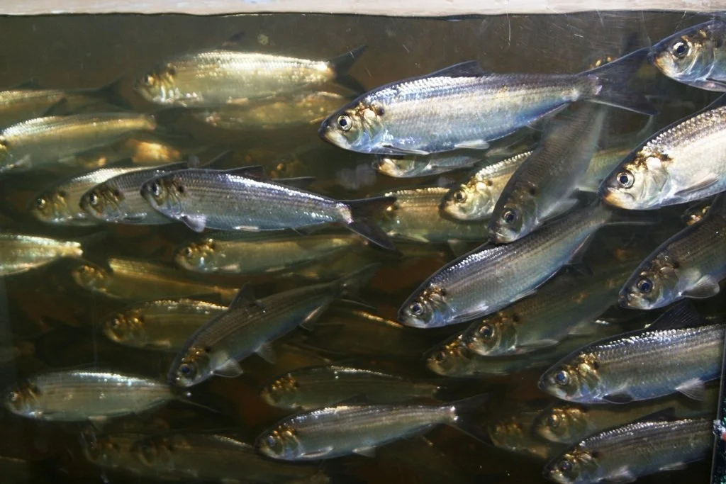
Image by John Burrows
The River's Silver Messenger: The Alewife
St. George Consulting — Living River Series
Introduction
Every spring, one of the great spectacles of the natural world happens quietly in Maine's coastal rivers — and most people drive right past it. Alewives (Alosa pseudoharengus) are small, silvery fish, no bigger than your hand, that spend most of their lives in the open ocean and then return in great, shimmering schools to the freshwater streams where they were born. In Maine, they are called "river herring," and their arrival each May is as sure a sign of spring as the peepers or the returning ospreys. For the St. George River watershed, alewives are not just a seasonal visitor — they are a keystone species, a thread that connects ocean and forest, predator and prey, past and present.
Natural History
Alewives are anadromous fish, meaning they live in saltwater but spawn in freshwater — a life strategy they share with Atlantic salmon and sea-run brook trout. Adults typically spend two to five years at sea, growing on a diet of zooplankton, before an irresistible biological signal draws them back to their birth river. They navigate using the unique chemical signature of their home stream, a sense of place encoded in their biology at hatching.
Spawning occurs in slow-moving water — ponds, lake margins, and sluggish stream sections — where females release hundreds of thousands of eggs. The adults, exhausted and battered, drift back downstream to the sea. The eggs hatch quickly, and by late summer the young alewives — called "juveniles" — make their own first journey to the ocean, completing a cycle that has played out on this coast for thousands of years.
Role in the St. George River Watershed
Few species matter as much to as many others. When alewives run, nearly every predator in the watershed takes notice.
Ospreys and bald eagles wheel over the river in May, plucking fish from the surface. Great blue herons stand motionless in the shallows, waiting. River otters and mink work the stream banks. Striped bass and bluefish follow the schools into tidal reaches. Even brook trout gorge on the juveniles in late summer as they drift toward the sea.
But the alewives' contribution extends beyond what feeds on them directly. When they spawn in large numbers and die, their carcasses decompose along stream banks and in the water, releasing marine-derived nutrients — phosphorus, nitrogen — that fertilize the riparian zone. Riverside trees, shrubs, and plants along the St. George benefit from this nutrient pulse in ways that are only recently being understood by ecologists. In this sense, alewives are ocean nutrients delivered deep into the landscape.
Freshwater mussels — another species in this series — filter the water that alewife larvae develop in, and research suggests the two species benefit each other in a positive feedback loop of water quality and larval survival.
The Wabanaki people of this region understood alewives' importance intimately. They were a crucial spring food source, arriving predictably when winter stores were running low. Penobscot and other Wabanaki communities used weirs — basket-like fish traps constructed in streams — to harvest enormous quantities of alewives, which were dried and smoked for later use, rendered for oil, and used as fertilizer for crops. The right to fish for alewives was one of the most important seasonal resources tied to a community's territory. Many of Maine's traditional fishing sites remain significant to Wabanaki people today.
Seasonal Notes
The run begins in late April, with peak activity typically in May along the St. George system. Watch for rippling, crowded schools just below dams and fish passages in Thomaston and Warren — the fish visibly bunch where the passage narrows. By June, most adults have returned to the sea. The juveniles move downstream in August and September, a more subtle but no less remarkable migration. On warm late-summer afternoons, look for flickers of silver in slow pools near the river's mouth.
Fun Fact
A single female alewife can carry up to 300,000 eggs — and the schools they travel in can number in the millions. In the 18th and 19th centuries, Maine towns commonly held "alewife rights," legally managing who could harvest fish from specific streams. The fish were so economically important that towns went to court over them.
Want to Learn More?
- Maine DMR — River Herring — Maine's management and monitoring of alewives and blueback herring.
- NOAA Fisheries — Alewife — Species biology, range, and conservation status.
- Atlantic States Marine Fisheries Commission — River Herring — The interstate management body overseeing alewife recovery along the coast.
- Penobscot River Restoration Trust — An inspiring model of dam removal and fish passage restoration with direct relevance to alewife recovery throughout coastal Maine.
The Living River blog series is published by St. George Consulting in support of the Georges River Land Trust and the Maine Council of Trout Unlimited. To explore the important work these organizations are doing to conserve and restore Maine's landscapes, visit georgesriver.org and tumaine.org.